Perhaps counterintuitively, sediment layers are more likely to remain intact on the seafloor than on land, so they can provide a better record of the region’s history. The seafloor is a more stable, oxygen-poor environment, reducing erosion and decomposition (two reasons scientists find far more fossils of marine creatures than land dwellers) and preserving finer details.
A close-up view of a core sample taken by a vibracorer. Scientists mark places they plan to inspect more closely with little flags.
Credit:
Alex Ingle / Schmidt Ocean Institute
Samples from different areas vary dramatically in time coverage, going back only to 2008 for some and back potentially more than 15,000 years for others due to wildly different sedimentation rates. Scientists will use techniques like radiocarbon dating to determine the ages of sediment layers in the core samples.

Microscopic analysis of the sediment cores will also help the team analyze the way the eruption affected marine creatures and the chemistry of the seafloor.
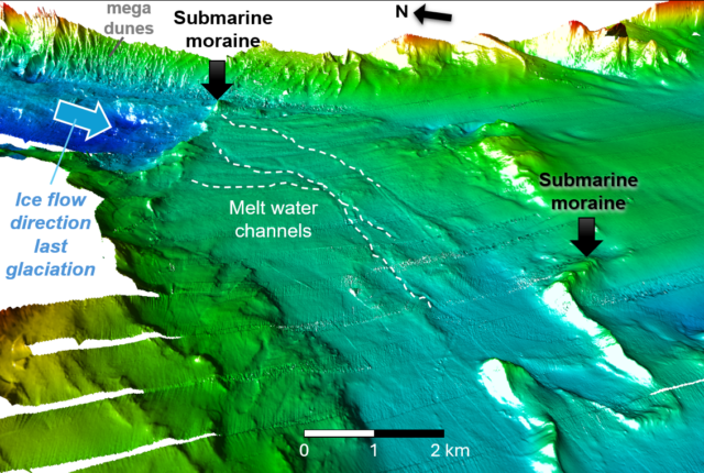
“There’s a wide variety of life and sediment types found at the different sites we surveyed,” said Alastair Hodgetts, a physical volcanologist and geologist at the University of Edinburgh, who participated in the expedition. “The oldest place we visited—an area scarred by ancient glacier movement—is a fossilized seascape that was completely unexpected.”

This feature, too, tells scientists about the way the water moves. Currents flowing over an area that was eroded long ago by a glacier sweep sediment away, keeping the ancient terrain visible.
“I’m very interested in analyzing seismic data and correlating it with the layers of sediment in the core samples to create a timeline of geological events in the area,” said Giulia Matilde Ferrante, a geophysicist at Italy’s National Institute of Oceanography and Applied Geophysics, who co-led the expedition. “Reconstructing the past in this way will help us better understand the sediment history and landscape changes in the region.”

The team has already gathered measurements of the amount of sediment the eruption delivered to the sea. Now they’ll work to determine whether older layers of sediment record earlier, unknown events similar to the 2008 eruption.
“Better understanding past volcanic events, revealing things like how far away an eruption reached, and how common, severe, and predictable eruptions are, will help to plan for future events and reduce the impacts they have on local communities,” Watt said.
Ashley writes about space for a contractor for NASA’s Goddard Space Flight Center by day and freelances as an environmental writer. She holds master’s degrees in space studies from The University of North Dakota and science writing from The Johns Hopkins University. She writes most of her articles with a baby on her lap.


